


A reckoning for the WUI
(And all Californians will pay for it)

Volume 3, Number 49 - Thursday, Feb. 13, 2025
Published every Monday and Thursday
Perspective
LAST JULY, I wrote about the WUI (wildland-urban interface) and said at the time (read it HERE) that I believe just about all of California is in the WUI.
I won’t repeat what I wrote at the time, but the January firestorms in Los Angeles seem to have driven home my point. The very nature of California — and our penchant for building homes close to nature — have made us all at risk.
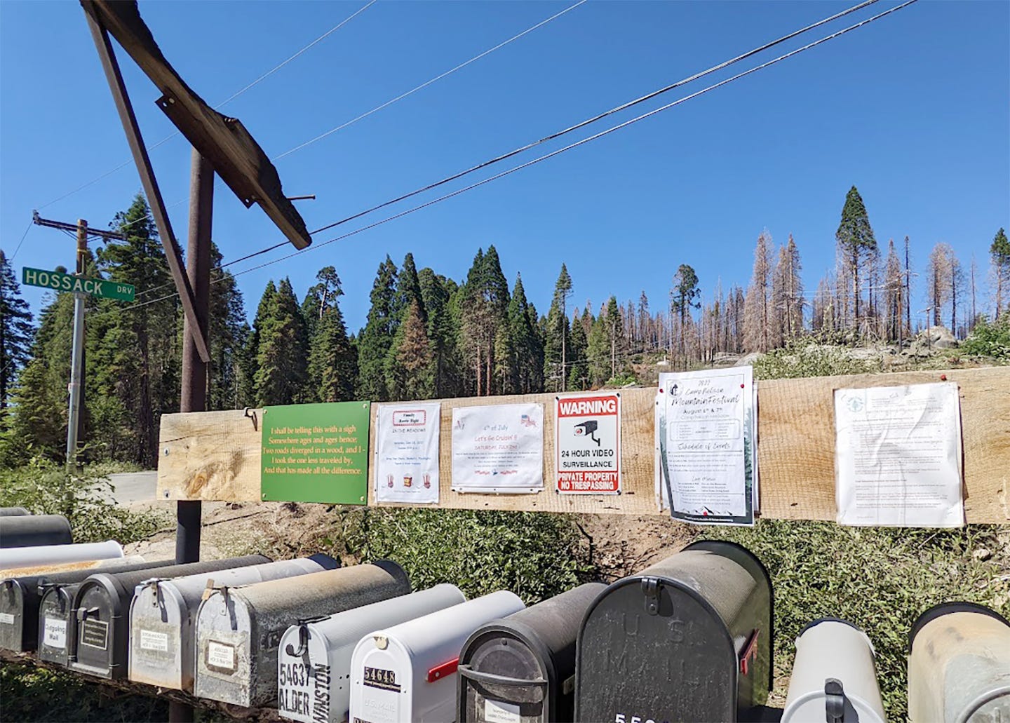
The photo above shows some mailboxes in the Tulare County mountain community of Sequoia Crest. It’s one of the Upper Tule communities surrounded by public land and happens to be just down the road from the Alder Creek property now owned by Save the Redwoods League.
I wrote about the impact of the 2020 Castle Fire on the community and surrounding forestland HERE.
Since that fire, California has seen many more neighborhoods close to wildlands burn, and thousands of homes have been lost in a state that already had a housing shortage.
As CalMatters reported HERE two days ago, more than 2 million acres of local land in California have been designated as “high” or “very high” fire danger areas.
California is over 100 million acres in size, so that 2 million acres might not seem like much, but please notice the designation of “local land.”
About 47% of California is federal land — and in some counties, the percentage is much higher.
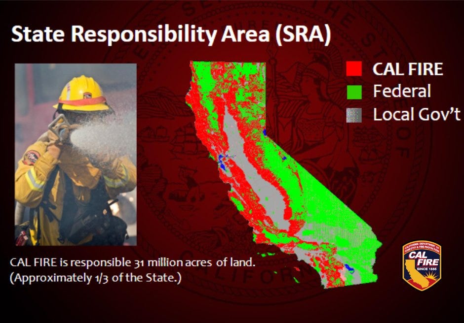
Cal Fire is responsible for 31 million acres of land, the feds are responsible for about 47.8 million acres, and local governments are responsible for the rest.
The state agency’s process for identifying fire hazard severity zones has been contentious, with efforts thwarted partly because people feared the maps would increase insurance costs. With the latest fires in Southern California, Gov. Gavin Newsom ordered updates (see HERE) of the maps and building standards.
As CalMatters reported:
Statewide 800,000 acres of land with local responsibility were classified in 2007 as “very high” hazard, the only category used at the time. The new maps now designate 1.16 million acres as “high” and an additional 247,000 acres as “very high,” according to a press release from the governor’s office. Fire Marshal officials said they cannot estimate what percent of total acreage that encompasses until local authorities review and adopt the maps.
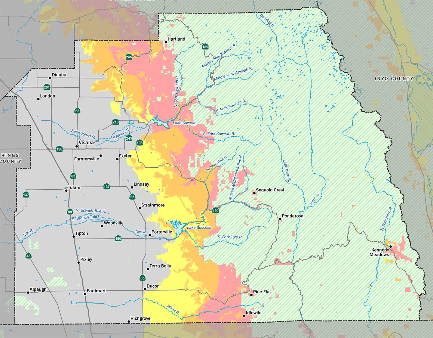
Below is a copy of the 2024 draft map for Tulare County. More than 52% of the county is federal land, including Sequoia and Kings Canyon National Park and Giant Sequoia National Monument (Sequoia National Forest).
On this map, red is “very high,” orange is “high,” and yellow is “moderate” severity — as determined for the June 2023 draft. All the red areas within the green federal land are “very high” severity and are small communities or privately held land surrounded by federal land.
How much this map may change remains to be seen as CalFire continues releasing updates as directed by the governor.
What does this mean for Californians?
In theory, the updated maps will better prepare firefighting agencies and force higher standards for new buildings.
As a practical matter, identifying the severity of the risk of private land adjacent to federal land doesn’t mean much (in my opinion) if the federal land isn’t going to be managed to reduce the risk of a wildfire that can be expected to move onto surrounding land.
And what is going on with that federal land?
We’ll have to see once the dust settles with the change of administration.
In the meantime, Californians can expect to pay more for insurance, no matter where they live.
As The New York Times reported two days ago (gift link HERE), California’s FAIR Plan — insurance of last resort for people with property in high-risk areas (if they can afford it) — will be allowed to assess insurance companies doing business in the state to cover a billion dollars in losses it can’t cover.
Secretary of Agriculture confirmed
Earlier today, the Senate voted 72-28 to confirm Brooke Rollins’ nomination to serve as Secretary of Agriculture. The USDA is over the Forest Service, which is responsible for the conservation of 41 groves of giant sequoia.
Rollins’ confirmation was supported by the Farm Bureau, as noted HERE.
Following her confirmation, the Sierra Club issued a statement (HERE), including this:
“Agriculture is the backbone of the U.S. economy, and it is currently facing a tumultuous period with a climate crisis, tariff battles, a labor shortage, and spreading bird flu concerns. The U.S. Department of Agriculture needs a strong and experienced leader who will advocate for U.S. farms, forests and food security, and see the country through this period. We will be watching to ensure that Secretary Rollins is up to the challenge, or if she will defer to corporate interests over the American farmer.”
Wildfire, water & weather update
Impressive snow above 7,000 feet? We can hope, and the National Weather Service, Hanford, said HERE that it’s likely.
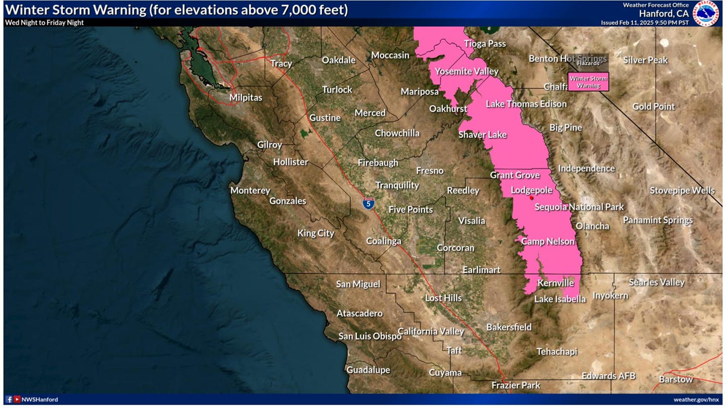
Still, California Drought Map (HERE) shows the Sierra Nevada from Mariposa County south in “moderate drought.”
Did you know you can comment here?
It’s easy to comment on items in this newsletter. Just scroll down, and you’ll find a comment box. You’re invited to join the conversation!
Thanks for reading!
Thanks Claudia for this very helpful overview. My other sources of those don't provide what you do.
You write that "identifying the severity of the risk of private land adjacent to federal land doesn’t mean much (in my opinion) if the federal land isn’t going to be managed to reduce the risk of a wildfire that can be expected to move onto surrounding land." Yet research has shown the opposite trend -- the majority of large and destructive fires (to human infrastructure) actually begin on and move from private land onto public land, not vice versa. See for example Downing et al. 2022, "Public lands are not the primary source of fires that destroyed the most structures." https://www.nature.com/articles/s41598-022-06002-3. So reducing fire hazard on *private lands* in the WUI is actually most important if the goal is to reduce structure losses, etc. Moreover, as has also been shown in many studies, increasingly extreme fire weather, longer fire seasons and growing atmospheric aridity (all related to climate change) are becoming the primary drivers of fire behavior in CA. Without addressing these issues, it's we cannot expect fire behavior will become less intense or structures less threatened by fire, even with increased fuel reduction. A lot of peer-reviewed science supports this connection, for example https://agupubs.onlinelibrary.wiley.com/doi/full/10.1029/2018EF001050 and https://iopscience.iop.org/article/10.1088/1748-9326/ab83a7?ftag=MSF0951a18 and https://www.pnas.org/doi/abs/10.1073/pnas.2213815120